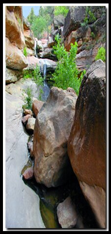
Pine Creek is a wonderful place to go and escape the crowds and heat in Zion Canyon. This little known gem takes a little effort to get to, but once there, take your shoes off, wiggle your toes in the water and enjoy the day. Along the short, quarter-mile hike there is some boulder hopping that may be difficult for some.
At a Glance Photo Album:Pine Creek pictures Trail Map:Pine Creek Trail Map Day Hike: Yes. Distance: .25 miles Average Hiking Time: 1 hour Difficulty: Moderate, but short involving some boulder hopping. Permits: Not required. Trail Conditions: The path is through the Pine Creek stream and along the sides of the water, over boulders and through sand. There is a little bit of boulder hopping, slippery rocks to navigate and areas of unsure footing. Trailhead: Pine Creek Bridge - South side of the Zion-Mt. Carmel Tunnel, near Canyon Junction Trailend: Same as starting point Trail Access: The Zion-Mt. Carmel Highway is open year-round. Off the Beaten Path: Yes Classic Zion Hike: No Best Season: May-September when the water is warm. Water Availability: It's easier to bring your own, but the hike is along a creek. Restrooms: East side of the Zion-Mt. Carmel Tunnel, the Zion Human History Museum and the Zion Canyon Visitor Center.
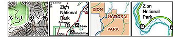
Trailhead - From the east side of Zion National Park, pass through the Zion-Mt. Carmel Tunnel. Drive down the steep, winding switchbacks to the bottom of the hill where the road levels out. There is a small turnout on the right side of the road to park at. This area is called the Pine Creek Bridge. Canyon Junction, the spur to Zion Canyon is .25 miles from this area. If you see this junction you have gone too far. There is an obvious path of use from the parking area to the creek. Make your way along the creek to the waterfall. There are dirt paths along most of the obstacles, but be prepared to climb and scale rock. This is a beautiful area of Zion National Park where few venture. Dried streaks on the sandstone walls show where water levels have reached at different times. Pine Creek is a flash food area and should not be entered if it looks like it will rain or is raining up canyon.
Directions to Zion National Park
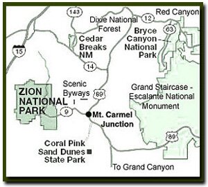
From the North: Travel I-15 south, past Beaver. exit on Hwy 20. Follow US-89 to Mount Carmel Junction. Take SR-9 to Zion's east entrance.
From Arizona: Travel US-89A through Fredonia, Arizona and Kanab Utah. Follow US-89 to Mount Carmel Junction. Take SR-9 to the east park entrance.
From the South: Travel I-15 north. Take exit 16 and travel through Hurricane to LaVerkin. Continue on SR-9 to the south entrance of the park. SR-9 through Zion National Park is always open and is also called the Zion-Mt. Carmel Highway. See restrictions for RV's.
The beautiful Pine Creek Waterfall is located just .25 miles off the Zion-Mt. Carmel Hwy (SR 9).
Lodging and services are available on the gorgeous east side of Zion National Park, where guests are close to Zion National Park (12 miles), Bryce Canyon National Park (60 miles), Cedar Breaks National Monument (45 miles), Coral Pink Sand Dunes (12 miles), and the North Rim of the Grand Canyon (85 miles). It's where city traffic is absent and the skies are bright and clean.
There is flash flood debris along the sides of the creek as a reminder. Check the weather conditions before entering this area. The Zion Canyon Visitors Center has the current weather conditions posted and has flash flood warning information.
The Waterfall Waterfalls are not abundant in Zion making this one a treasure. This beautiful area is easily accessed compared to similar places in the park. Swimming in the pool of water is permissible. There is a sandy area around the water surrounded by large boulders that makes a nice place to take shoes off and wade in the water. Tiny canyon tree frogs are found throughout the Pine Creek area. Take care not to step on these tiny creatures or their tadpoles.
Best Features
Access without getting on the Zion Canyon Shuttle. Along this trail there are beautiful views of the Beehives, West Temple, Mount Spry, Streaked Wall, East Temple and the Great Arch. There are various hoodoos on the mountain tops visible along the trail.
Trail Options: Hiking past the Pine Creek Waterfall is an option. There is a trail to the right of the falls that goes to the top and then the Pine Creek route can be followed past the falls or begin higher in the creek and end at the waterfall.
Please take care of this beautiful area. Break down any creations made in the sand and take all trash with you.
Beta: Coordinates and other trail and canyoneering information by Zion Park search and rescue veteran team member Bo Beck and zionnational-park.com author Tanya Milligan.
To post trip reports, offer corrections, updates, or for more information please visit the Zion National Park Forum
Suggested Gear: A sturdy pair of shoes are recommend to hike the trails in Zion National Park. Many quality shoes will help grip the rocks and prevent injury.
Mileage from
Mt. Carmel Jct.
Zion National Park 12
Bryce Canyon 60
Grand Canyon 85
Cedar Breaks 45
Grand Staircase 9
Dixie Forest 22
Sand Dunes 11
Coyote Butte 57
Red Canyon 47
Tuweep 90
Stay in the heart of the parks, Mount Carmel Junction, and visit the treasures of the Southwest and Utah.
This is my new favorite quote:
"I don't know who Tanya Milligan is, but I mean zionnational-park.com
It's a better site than the NPS's anyway."
Written by the authors of the book: Favorite Hikes in and around Zion National Park


 Trailhead - From the east side of Zion National Park, pass through the Zion-Mt. Carmel Tunnel. Drive down the steep, winding switchbacks to the bottom of the hill where the road levels out. There is a small turnout on the right side of the road to park at. This area is called the Pine Creek Bridge. Canyon Junction, the spur to Zion Canyon is .25 miles from this area. If you see this junction you have gone too far. There is an obvious path of use from the parking area to the creek. Make your way along the creek to the waterfall. There are dirt paths along most of the obstacles, but be prepared to climb and scale rock. This is a beautiful area of Zion National Park where few venture. Dried streaks on the sandstone walls show where water levels have reached at different times. Pine Creek is a flash food area and should not be entered if it looks like it will rain or is raining up canyon.